Uganda, famously known as the Pearl of Africa, offers a diverse range of safari experiences,…
Mount Speke
Mount Speke, The second-highest peak in the Rwenzori range is Mount Speke, which is in the Rwenzori Mountains National Park. The upper Bujuku Valley is surrounded by a triangle made up of Mount Speke, Mount Baker, and Mount Stanley. To the south-southwest, Mount Speke is 3.55 kilometers (2.21 miles) away. The area where these mountains are found is called “The Mountains of the Moon.”
All of the mountains in this group have a number of rough peaks. Vittorio Emanuele (4,890 meters (16,040 feet)), Ensonga (4,865 meters (15,961 feet)), Johnston (4,834 meters (15,860 feet)), and Trident 4,572 meters (15,000 feet) are the tops of Mount Speke.
They had to be approved by the British Protectorate of Uganda, which was in charge of the area at the time, even though the names came from an Italian royal family tradition. This hill was named after John Speke when European explorers first came to the area to look for the source of the Great Nile. Speke drew the White Nile’s source in 1862, even though he had never hiked to the top of this mountain.
All of the mountains in this area are named after travelers who came to Africa in the early days of colonialism and were related to each other. Because it rains so much, Mount Speke is cut through by many streams and rivers, and the plants that grow there look thick.
How to Get to Speke Mountain
Day 1: From MIHUNGA GATE (1651 meters above sea level) to NYABITABA CAMP (2651 meters above sea level),
The hike to the top of Mount Speke starts at the Park’s gate in Mihunga and follows the Central circle trail. The air coming down from the mountain makes you feel energized for the trip ahead as you get closer to the park gate at the end of the drive to the gate. The trail starts by going through farmland and ends at the park border. The trail then goes through a thick forest along the Mubuku River and crosses its branch, the Mahoma River. To get to Nyabitaba camp, it starts a long, steep climb up a big hill.
Gorilla trekking and mountain tops in the Rwenzori range
In this part of the walk, you might hear chimps and see black-and-white colobus, blue monkeys, and the brightly colored Rwenzori turaco.
Most of the time, the walk takes between 6 and 7 hours.
Second day: NYABITABA to John Matute Camp DAY 2 (3,505 meters above sea level)
You can get to the Kurt Shafer Bridge from Nyabitaba by taking the path that goes through the forest. The bridge is right below where the Mubuku and Bujuku rivers meet. As you move through the bamboo wood, you’ll have to cross a long, slippery stretch of moss-covered rock. Before going into the area of huge heather, lobelia, and groundsel, you can see Mount Stanley and Speke from the Nyamuleju rock shelter. You will get to John Matte Hut after a long walk through the mud. Today is the longest day on the Central Circuit Trail. The John Matte hut is where we had dinner and slept.
Most of the time, the walk takes between 7 and 8 hours.
John Matte’s bungee camp on Day 3 (3962 meters above sea level).
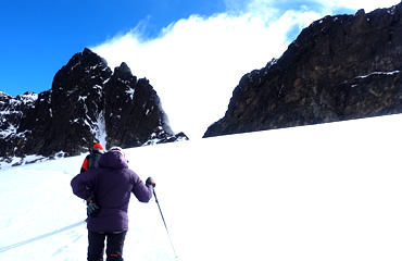
The view from the top of Mount Rwenzori
From John Matte Hut, the trail goes down to cross the Bujuku River and join the Lower Bigo Bog, which is full of huge lobelias. To get across the bog, they finally have to jump from tussock to tussock. From the upper Bigo bog, you can always get to Bujuku Lake, which has views of Mount Baker and Mount Stanley to the west and south. The Bujuku Hut is in a gorge below Stuhlmann’s Pass, in the shade of Mt. Baker and Mount Speke. People who want to climb Mt. Stanley and Mount Speke should stay at this camp to get used to the altitude.
The Bujuku Hut for dinner and the night.
In general, the walk takes four to five hours.
Day 4: BUJUKU – MT. SPEKE (4890 m) – BUJUKU – JOHN MAATE
Early in the morning is the best time to start the hike to the top of Vitorio Emanuele. You will have to go through Stuhlmann’s Pass (4192 m above sea level), which offers stunning views of Virunga National Park in Rwanda. It takes 4 to 5 hours to get to the top. Get ready to go down from Vittorio Emanuele to Bujuku camp, where you can see the Bujuku valley and lake, as well as the Margherita and Albert peaks on Mt. Stanley and Mt. Baker. After going back to Bujuku, you will continue to John Maate Camp for the night.
It usually takes between 3 and 4 hours to go down.
Day five: John Maate to Nyabitaba to Nyakalengija (5th day) (1615 meters above sea level)
The path goes along the Kichuchu rocks below Guy Yeoman. After Kichuchu, the muddy path goes through a bamboo forest and over the River Mubuku twice. It then goes up to Nyabitaba to finish the loop. Keep going down until you reach Nyabitaba Camp. Your trip will end at Mihunga Gate in the evening, and you will spend the night at your hotel in Kasese.
It takes seven to eight hours to go down.
Some other mountains in the Rwenzoris range are: Mount Baker
Mount Baker is the sixth tallest mountain in Africa. Its highest point, Edward Peak, is 4844 meters (15,892 feet) high. It is so close to Mount Stanley. The triangle made by Mount Stanley, Mount Baker, and Mount Speke is the upper Bujuku valley.
Sir Samuel Baker was the first person from Europe to see Lake Albert, which is northeast of Mount Rwenzori. This food is named after him.
The twin peaks, the Margherita glacier, Mount Speke, and the amazing beauty of the Rwenzori Mountains can all be seen from the top of Mount Baker.
Giant Mountain
The Rwenzori Mountains have Mt. Gessi and Mt. Emin, which are north of the triangle formed by Mount Stanley, Speke, and Baker. It was named for Romulo Gessi, an Italian traveler who found the source of the Nile. There are also two peaks on the mountain: Iolanda (15,470 ft.) and Bottego (15,470 ft.). Mount Emin is close by; there is a small gap between them.
From the Mugusu valley, the trail to the top goes through groundsel woods to the Roccato pass. From there, it goes through heavy brush and slabs to the ridge between the peaks. These peaks used to have ice on top of them, but those melted away.
Mount Emin
The Rwenzori Mountains are home to Mount Emin, which is 15742 feet high. It was named after a traveler from central Africa named Mohammed Emin Pasha. Even though there isn’t any snow on the mountain, it is thought to be the fourth highest in the Rwenzori range and the sixth highest in Africa.
Umberto (1574ft) and Kraepelin (15720ft) are the two highest points on the mountain. They are both between the borders of Uganda and DR Congo, which makes it easy to get to from the Congo side. This hill in the Rwenzori Mountains National Park is usually climbed from the southwest corner of the Ridge. It is also easy to get to from the Mugusu Valley, which goes into Congo.
The Mount Stanley
The tallest mountain in the Rwenzori Mountains is Mount Stanley. The Democratic Republic of the Congo and Uganda are both next to these mountain regions. This beautiful mountain rises from jungle and strange bogs to a group of sharp peaks surrounded by the most glaciers in Africa. In the African Rift System, Mount Stanley is a fault block mountain that rises between two rifts. They were formed in the last 10 million years and are made up of gneiss and quartzite. Mists and rain cover the mountains almost all the time, and thunder and lightning happen often.
Related Posts