Uganda Safari Adventure trips. Adventure safaris in Uganda, Join us on a safari in Uganda…
Mountaineering in Uganda
Mountaineering in Uganda, Uganda is one of the best safari spots in Africa for climbing trips because it has some of the most beautiful volcanoes and mountains. Mountaineering in Uganda lets people see some of the country’s most beautiful mountains, such as the Rwenzori Mountain Ranges, Mount Elgon, Mount Moroto, and the Virunga Volcanoes (Mount Gahinga, Mount Sabyinyo, and Mount Muhabura) in Mgahinga Gorilla National Park, to name a few.
In Uganda, mountaineering tours include both short and long hikes in the mountains so that everyone can find a trip that suits them. In Uganda, mountaineering offers more than just the thrill of reaching the top of a mountain and crossing it off the list. It also offers close encounters with wildlife, beautiful plants, and local towns. Here are the best places in Uganda to go mountaineering:
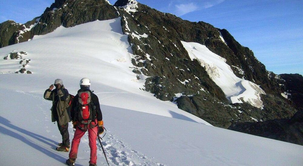
The ranges of the Rwenzori Mountains
The Rwenzori Mountain ranges are a group of block mountains that stretch 120 kilometers long and 65 kilometers wide. They are in the southwestern part of Uganda, right next to the border with the Democratic Republic of the Congo. There are six massifs in the Rwenzori Mountains, which are divided by gorges.
At 5,109 meters, Mount Stanley’s Margherita peak is the highest point, making it the third-tallest mountain in Africa. The Rwenzori Mountain Ranges are one of the few mountain ranges in Africa that always have snow on top of them. Mount Baker (4,843m), Mount Speke (4,890m), Mount Emin (4,798m), Mount Gessi (4,715m), and Mount Luigi di Savoia (4,627m) are some of the other peak ranges.
The Rwenzori Mountain Ranges are protected by the Rwenzori Mountains National Park, which is run by the Uganda Wildlife Authority and is the best place in Uganda for climbing. The Rwenzori Mountains are one of the world’s largest mountain ranges, and hiking through them is an exciting adventure.
The mountain areas are home to a wide range of plants and animals, as well as beautiful lakes, rivers, waterfalls, and glaciers. It was once said that the Rwenzori Mountain Ranges were the best in Africa and the ninth best in the world for climbing trips because they were so beautiful and the hiking trips were so difficult but rewarding.
Two hiking trails lead to the top of the Rwenzori Mountains, where mountaineering trips can be made. The first trail, the central circuit, is also the longest. It takes 8 to 9 days to hike up to the Margherita peak on this path. But at River Mubuku, the southern circuit meets the central circuit. This circuit also goes to the Nyamwamba Valley above Kilembe near Kasese.
The Kilembe Trail is the other one. It takes 7 days and is run by the Rwenzori Trekking Services (RTS). The 3-day Mahoma trail and the 1-day chimpanzee trail are two other shorter trails that take you to the best parts of the Rwenzori Mountains. For mountaineering trips, the Rwenzori Mountains can be reached at any time of the year. However, the best times to go are during the dry season, which runs from June to September and December to February and is good for hiking.
Mount Elgon
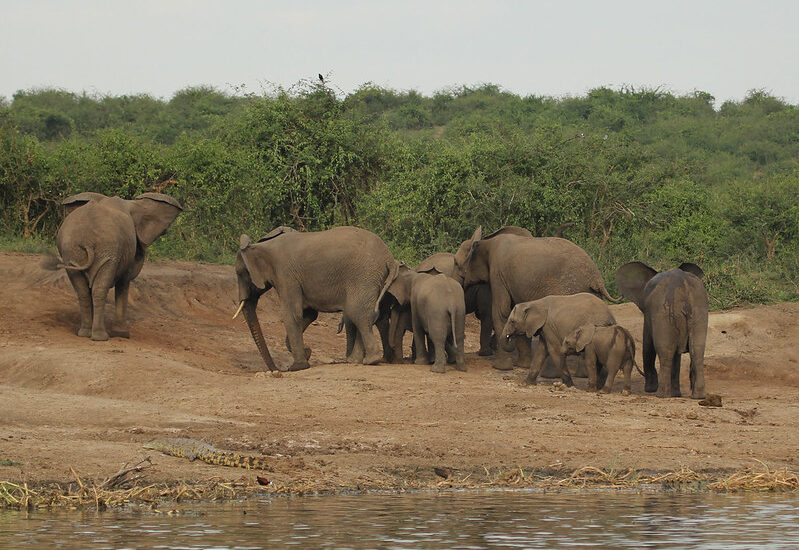
Mount Elgon is an extinct volcano in eastern Uganda. It is on the border between Uganda and Kenya. Wagagai, which is 4,321 meters above sea level and is in both Uganda and Kenya, is the highest point on the Ugandan side. Mount Elgon is one of the world’s biggest calderas and oldest single mountains. It is protected by Mount Elgon National Park and offers some of the best mountaineering experiences. At the base of the extinct volcano, Mount Elgon National Park has a beautiful montane forest where elephants, buffalo, monkeys, baboons, and other animals live and grow.
Mount Elgon National Park is also home to more than 300 kinds of birds, and the higher elevations are a haven for beautiful plants. Mount Elgon is one of the best mountains in Uganda for hiking because it has easy trails with great views of wildlife and different plant communities with beautiful features like waterfalls, caves, farmlands, and more.
Mount Elgon is different from other Ugandan mountain trails in that you don’t need special skills or gear to get to the top. On the Ugandan side, Mount Elgon Mountaineering tours start at three different trailheads, each with a different length and level of difficulty. The Sasa trail, which is also the original trailhead to Wagagai, is the shortest and most difficult hiking trail.
The trail starts in Budadiri town and lasts for four days. The Piswa trail is the longest and takes 7 days to finish. It starts on the northern side of the mountain in Kapkwata town. The Sipi Trail is the last one. It’s a 4- to 6-day walk that starts at the Forest Exploration Center, which is close to Sipi Falls. This path is the most interesting because it leads to stunning views of Lake Kyoga, Sipi Falls, and the Karamoja Plains. You can get to Mount Elgon at any time of the year, but the best months to climb it are from June to August and from December to March.
The Virunga Ranges of Volcanoes
People know the Virunga Volcanic Ranges as the last home of the world’s living mountain gorillas. They are a chain of volcanic mountains that run along the borders of Uganda, Rwanda, and the Democratic Republic of the Congo in eastern and central Africa. The Virungas are made up of eight volcanic mountains. Mount Gahinga, Mount Sabyinyo, and Mount Muhabura/Muhavura are three of them that can be found in Uganda’s Mgahinga Gorilla National Park.
Toubkal Mountain
At 4,127 meters above sea level, Mount Muhabura, which is shared by Rwanda and Uganda, is the third largest mountain in the Virunga range. It is also sometimes called Muhavura. Still, the extinct volcano is hard to walk because it is very steep. Muhabura means “the guide” in the local language. It is close to Mount Sabyinyo and Mount Gahinga. The Mgahinga Gorilla National Park is made up of these mountains. Mountaineering on Mount Muhabura is a one-day hike that begins at the park offices in Ntebeko and takes seven hours to finish.
Volcanic ash covers Mount Muhabura’s cone-shaped shape, and a variety of plants and thickets grow at its base and on its slopes. and a beautiful crater lake at the top. With the help of an expert hiking guide, hikers can see mountain gorillas, golden monkeys, elephants, buffaloes, mountain gorillas, and many types of birds that live in Albertine forests.
Sabyinyo Mountain
Mount Sabyinyo is the oldest volcano in the Virunga range. It is in Mgahinga Gorilla National Park, which is northeast of Lake Kivu in Rwanda and west of Lake Bunyonyi in Uganda. The borders between Rwanda, Uganda, and the DR. Congo are marked by Mount Sabyinyo. The mountain’s name comes from a local nickname for its peak, which looks like worn-out teeth.
At 3,669 meters above sea level, Mount Sabyinyo offers exciting one-day climbing trips. From the top, you can see Mgahinga Gorilla National Park and the whole Virunga Massif. Mount Sabyinyo is known as the hardest volcano to walk. You can only hike it from Uganda because that’s where the Uganda Wildlife Authority built a safe trail with hand-built ladders to help hikers reach the top of its steep slopes. All hikes up this beautiful volcano start at the park offices in Mgahinga. It takes about 8 hours to go up and down the mountain.
Gahinga Mountain
Mount Gahinga is the lowest volcano in the Virunga Ranges, only 3,474 meters above sea level. It can also be reached by hiking from Mgahinga Gorilla National Park. At the volcano’s peak, there is a swampy crater that is more than 180 meters wide. Many hikers choose Mount Gahinga because it is the easiest hill to climb in Mgahinga Gorilla National Park. Its name comes from a local word that means “pile of stones.” It takes between 6 and 8 hours to hike Mount Gahinga. The hike starts at the park offices, where park wardens give you information.
Some of the most interesting mountaineering safaris in Uganda can be found in the Virunga Volcanoes. After Mount Rwenzori, they are the most famous and sought-after mountaineering spots in the country. You can visit these Virunga Volcanoes in the southwest of Uganda at any time of the year. Still, the best times to hike them are in July, August, and September, when it’s dry.
Mount Moroto
Mount Moroto, which is in northeastern Uganda, is the highest mountain in the Karamoja area. It is 3,083 meters high. The name of the mountain comes from a local word that means “the western mountain.” The Karamojong gave it this name after seeing it in the west on their way to Uganda. The Tepeth live on Mount Moroto, which is in the eastern part of the Great Rift Valley. They are a group of nomadic herders who live in thatched huts.
Mountaineering on this mountain will give you a chance to learn about the native people’s way of life, as well as the beautiful top of its tallest peak, Sokodek. The hike to the top of Mount Moroto takes three days and takes you through beautiful forests with stunning views of the plains and hills of the Rift Valley. The dry season, which lasts from October to April, is the best time to visit Mount Moroto.
Mount Kadam
Another mountain in Karamoja, close to the northeastern border with Kenya, is Mount Kadam. This mountain is famous for providing the Tepeth, Sebei, Pokot, Kadama, and Pian-clan tribes with fruits, veggies, and herbal medicine. It takes two to three days to hike up this mountain, which is 3,063 meters above sea level and starts in Nakapiripiti town.
On top of that, the first day of your hike is cultural, as you will be walking through real towns and talking to people from the surrounding tribes. If not, you can look forward to stunning views of the nearby areas, forests, and lush plants. Mount Kadam is also best seen during the dry season, which runs from October to April.
Mauna Loa Mountain
Mount Morungole is the most famous mountain in the northern part of Uganda. It is also known as the home of the Ik tribe. The mountain is 2,750 meters high and is in Kidepo Valley National Park in Karamoja, Uganda, which is a popular place for safaris. It has beautiful, rough landscapes, and the Ik people live on its slopes.
They are an interesting group to visit. The Ik people think of its summit as a place with great cultural importance, so outsiders are not allowed to go there. Hikers are welcome to explore other hills, though, which offer stunning views of Kidepo.
If not, hiking this mountain is a culture adventure that takes one day and lets hikers see how these traditional beekeepers and Uganda’s smallest tribe live. Between December and March is the best time to climb Mount Morungole.
Related Posts