Uganda Safari Adventure trips. Adventure safaris in Uganda, Join us on a safari in Uganda…
Mountains in Uganda
Mountains in Uganda: Tanzania, Kenya, and other nearby countries get most of the attention when it comes to mountain climbing, leaving Uganda in the background. But the truth is that Uganda is one of the few places in the world where you can go on both peaceful wildlife tours and exciting mountain climbing in ancient tropical rain forests. Uganda’s mountains go from old jungles to high peaks covered in snow. Mountain climbs and Big 5 safaris are easy to combine in Uganda. If that’s not enough, you can add a beach vacation in Zanzibar, which is only an hour and a half away by plane.
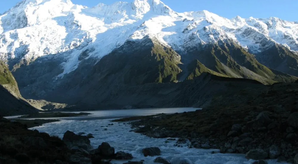
The mountains in Uganda offer the best and most unique experiences in Africa. You can climb the challenging 5,100-meter Rwenzori Mountain, reach the top of Mountain Elgon, which has the world’s largest crater, or enjoy the beauty of the Virunga Mountains.
Rwenzori Mountain
One of the most exciting and difficult mountains to walk in the world is the Rwenzori Mountains in Uganda. 996 square kilometers of fantasy plants, lakes, rocky outcrops, cliffs, high glaciers, and snow-capped peaks make up a unique and magical place. The peaks might not be as high as higher mountains in other places.
There is a 5,109-meter peak on Mount Stanley called Margherita Peak. This is Africa’s fourth-highest peak. But their isolation, changing weather, shockingly diverse plants, stunning views, and low number of tourists all make them appealing to daring hikers looking for a once-in-a-lifetime experience. The plants that grow on Rwenzori Mountain are special compared to other mountains in Uganda.
When it was made a national park in 1991, the Rwenzori Mountains were also named a World Heritage Site in 1994. In 2008, it was named a Ramsar site. These names show that the mountains are important to scientists around the world. The name “Rwenzori” means “Rainmaker” in English, which shows how important the mountains are in East and Central Africa.
The air is damp because it rains more than 3 meters a year in the mountains. This makes the lower sides have lots of plants and the higher levels have snow and ice. Because of climate change, glaciers have shrunk a lot in the last 100 years, but hikers will still have to cross ice walls and a lot of snow to get to the peaks during the rainy season.
Things to do on Uganda’s Mountain Rwenzori
Hiking in Mount Rwenzori
Hiking in the Rwenzori Mountains: You can only see the Rwenzoris on foot, and you need to be in good shape and used to doing endurance workouts. Recently, Margherita Peak was labeled as a technical climb. You don’t have to be an expert climber to finish it in the winter, but it is recommended that you have some experience. Treks that last from one to twelve days are available for everyone, from people who want to “bag all the peaks” to hunters who want to find the area’s rare species.
Private groups can also extend routes to give people more time to get used to the higher elevation or just enjoy the peace, quiet, and beauty of the mountains. There are two hiking trails that lead to the Rwenzori hills.
The Central Circuit starts in Nyakalengija, and the Southern Circuit starts in Kilembe. There are a lot of tricky parts in the Rwenzori Mountains in Uganda. Professor Scott Elliott was the first person to build the Southern Circuit in 1895. For many years, Luigi di Savoia was the first person to build the Central Circuit, which was the only way to get to the mountains.
Meetings between cultures
Many different kinds of people live in the mountains of Uganda. Bakos lived in Mihunga, a small town on the slopes of Mount Rwenzori, for almost 300 years. One could say that the beautiful views of the snow-covered hills are the reason they chose this spot for their community. The Bakonzo learned how to live on the sides of this huge mountain without running water or electricity.
They were self-sufficient because they grew their own food and used local herbs to treat illnesses. As part of your cultural trip, you will go to the Mihunga community tourism group. The quick change to modernism in our time has made old ways and habits less useful. The goal of the Bakonzo cultural group is to promote and protect the Bakonzo heritage.
The trail leads through rough terrain to the Mubuku river, whose name comes from the word for “clear water,” “ruboni.” The path goes with the flow of water. Locals will bring their crop and firewood, which is how the Bakonzo live. Keep an eye out for the beautiful Rwenzori Turaco, the francolin, sunbirds, cinnamon-chested bee-eaters, and other beautiful birds. Primates like colobus monkeys, red-tailed monkeys, and vervet monkeys can be seen on this nature walk.
Uganda’s tallest mountain, Mt. Rwenzoris, is Mountain Stanely.
This mountain peak is 5109 meters above sea level and is the tallest in Uganda. Not only that, but it is the third tallest mountain in Africa, after Mount Kenya (5197 meters) and Mt. Kilimanjaro (5895 meters).
Mount Stanley’s Margherita Peak:
Mount Stanley has one of the biggest glaciers in Africa that leads to the rock at the top of the Rwenzoris. This is where the Margerita peak is, which is the highest point in Uganda and the third highest in Africa. It’s too bad that the ice is melting so quickly; people are afraid that it will be gone forever in 30 years.
It usually takes at least seven days of trekking in the Rwenzori mountains to reach Margherita Peak, which is 5,109 meters high.
Mountain Elgon.
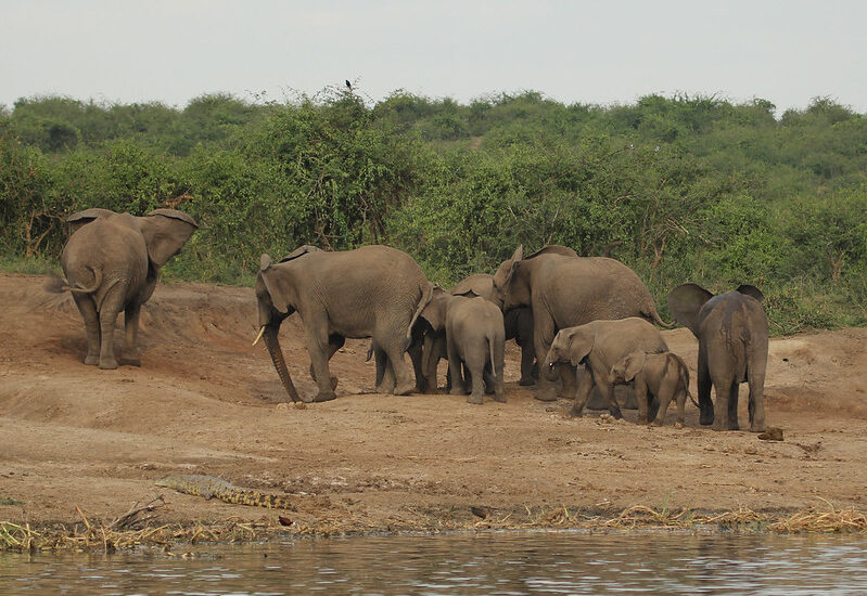
One of the most interesting mountains in Uganda is Elgon. Mount Elgon National Park is on the border between Kenya and Uganda. It is named after Mount Elgon, a shield volcano that erupted more than 24 million years ago but is no longer active. The surface area of Mountain Elgon is the best of any extinct volcano in the world, and its 4,321m top is the sixth tallest in Africa. The park’s surface area is 1,279 km2, with 1,110 km2 in the Ugandan section and 169 km2 in the Kenyan part. There are lots of animals in Mountain Elgon National Park. On the lower slopes of Mountain Elgon, you can find elephants, buffalo, and many small animals.
That’s where you can find primates like the blue monkey and the black-and-white colobus monkey. There are also about 300 kinds of birds in the park, such as the Tacazze sunbird and the lammergeier. It is in Mount Elgon National Park that the Sabiny and Bagisu tribes live. The Sabiny speak Sebei, which is a Nilotic language, and the Bagisu speak Lugisu, which is a Lumasaba language. The Bagisu see Mountain Elgon as a representation of their founder, Masaba, and call it that. In both groups, people grow for survival.
Mountain Elgon Trail for Hiking in Uganda
One great thing about Mount Elgon is that it has many mountain trails. The paths up Mount Elgon are open all year and don’t need any special gear, unlike other climbs in East Africa. Mount Elgon’s hiking tracks are less crowded than other East African trails, so you can enjoy the view without being bothered by other people. Mount Elgon has three main hike trails that are all different lengths and levels of difficulty.
Mountain Elgon in Uganda along the Sasa Trail
The Sasa Trail in Uganda’s Mountain Elgon is the shortest but hardest trail. It takes four days to go round-trip. The first way to get to Wagagai, the 4,321-meter top of Mount Elgon, was in this way. The trail starts in the town of Budadiri in Uganda’s Eastern Region, which is 1,250 meters above sea level. Start of the first day with a 1,650m climb. After that, the trail goes into the bush and leads to the Mudangi Cliffs, which can be reached by ladders. After that, you have to walk for two and a half hours through a lovely bamboo forest. The hike on Day 2 is easier, and on Day 3, you’ll reach Wagagai.
Mountain Trail in Uganda (Piswa Trail)
Instead of the Sasa Trail, you can take the Piswa trail on Mountain Elgon, which is easier. You will drive about 49 kilometers over the course of seven days. The trail starts at an elevation of 2,190 meters, close to the Kapkwata village on the north side of the mountain. People love this path because it has beautiful views of the Karamoja Plains in Uganda and the Kapeguria and Nandi Hills in Kenya.
Mountain Elgon Trail and the Sipi Trail
The longest trail is the Sipi trail. It’s 56 kilometers long and takes between 4 and 6 days to finish. It starts at the Kapkwai Forest Exploration Center, which is not far from Sipi Falls. One of its highlights is the part that goes through Tatum Cave, which is known for its old cave paintings. The Forest Exploration Center has opened three shorter trails that are between 3 and 7 kilometers long. People who have never hiked before or tourists who want to see Mount Elgon’s beautiful scenery and animals quickly should use these trails.
The park around Mount Elgon is home to more than 300 kinds of birds and has been named an Important Bird Area (IBA). People who like birds should keep an eye out for species that are in danger of going extinct, like the lammergeier. Watch out for the cinnamon-chested bee-eater, the African goshawk, and the African blue fly-catcher.
Mountain Moroto.
Mount Moroto is in the far eastern part of Uganda. It is the easiest place to get to see some of the most interesting bird species in the northeast. Most of them are along the western edge of their ranges, which starts in the south with Mount Elgon and goes up to Mountain Kadam and Morungole. Moroto is a forest reserve that covers a wide range of habitats, from dry thorn savanna to dry montane forest. From the village at the base of the mountain, you can see the beautiful dry thorn savanna and rocky slopes, but you have to walk a long way to get there.
You can easily add hiking in Mount Moroto to a safari in Kidepo Valley National Park, which is only 4 hours away, or to a camping trip in Karamoja’s Pian Upe fields. There are many interesting things to see and do in the area that are just waiting to be discovered. The far east has been cut off from the rest of the world for decades because of wars and other crises. Now that things have changed, it’s time for you to find out Uganda’s best-kept secret.
Things to Do in and around Mountain Moroto
As we already said, Mountain Moroto is in the Karamoja region, which is full of things to see and do, from untouched and authentic tribes to wild camping, wildlife safaris, and endless hiking options. The following things you can do are not the same as hiking Uganda’s Mountain Moroto.
Tribal and cultural experiences
You can do more than just hike in the Mountains of Uganda. You can also learn about the real culture of the people who live in or near the Mountains of Uganda. Karamoja is made up of flat, highlands that are between the mountains of South Sudan and Kenya’s Turkana region. It is home to unique people who still live a simple life, just like they have for hundreds of years. They live in a very dry area with beautiful scenery, and cattle are the most important thing in their society.
When you come here, you will see people from different groups wearing bright blankets and beads that have been pierced or marked in special ways. The Karamajongs are not at all like other groups in Uganda. Until recently, cattle theft from Kenya and South Sudan, which are close by, was a source of strife in the area. The area is still one of the least developed and most remote in Africa, and not many people have been there.
Seeing birds
Besides climbing, one of the most popular things to do on safari in the Ugandan Mountains is watch birds. We recommend that you visit the nearby Pian Upe Reserve, which is a great place for birdwatchers. This place has an amazing list of birds. This is a great place to see birds that are hard to see on a regular birding walk.
The Fox’s Weaver is Uganda’s only native bird species. Some of the best places to see it are Lake Opeta and Lake Bisina, which are part of the eastern stretch of the Kyoga system. To get from Mount Elgon to Moroto, you can stop at the lakes, but they don’t have any facilities. You can also tour them for a day from Soroti or Mbale.
The easier place to get to is Lake Bisina, which can be reached by a great dirt road that goes north from the main road between Mbale and Soroti near Kapiri. It’s best to see the numbers in March and April, but some can be seen all year long. The African Pygmy Goose and the Lesser Jacana can be found in calmer water with flowers. The Shoebill is also pretty common around the edge of the broad papyrus.
These birds live in the thick thorn savanna near the T-junction on the Mbale road, 11 kilometers from town. They are the Brubru and Eastern Violet-backed Sunbirds, the beautiful Silver bird, the White-bellied Go-away Bird, the Pygmy Batis, Jackson’s Hornbill, the Mouse-colored Penduline Tit, the Fawn-colored Lark, the Yellow-bellied Eremomela, and the African Grey Flycatcher.
Look for the beautiful Yellow-necked Spur bird, the Black-headed Plover, the Dark Chanting Goshawk, and the Crested Bustard. At the nearby airport, you can see Temminck’s Coursers and Plovers. When they are in pairs, D’Arnaud’s Barbets often get caught up in their strange tail-wagging duets. Listen for the clear sound of the pebbles hitting each other. This could mean that the Grey Wren Warbler is nearby.
The mountain Sabinyo, Uganda.
Mount Sabinyo is a volcano in the Virunga Mountains that is no longer active. The Virunga range also includes Mounts Karisimbi, Muhabura, Bisoke, Mikeno, Nyiragongo, Gahinga, and Nyamuragira. Mount Sabinyo is 20 meters away from its neighboring mountain, Muhabura, through a crater lake. In the original language, Sabinyo means “Old man’s tooth.” This is because, compared to the flat tops of nearby mountains, its steep peak looks like worn-out teeth.
Mount Sabinyo is 12,037 feet high and separates Uganda, Rwanda, and the Democratic Republic of the Congo. Elephants, buffalo, other wild antelopes, and mountain gorillas, which are in danger of going extinct, live on the mountain slopes. It is one of the hardest walks in the Virunga Ranges to get to Mount Sabinyo. It has many hills because the sides are rough and have craters and slopes. One of the most beautiful mountain ranges in Uganda is this one.
At the moment, you can only hike Mount Sabinyo from Uganda. There is no way through the rocky peaks on the sides of Congo and Rwanda. The government of Rwanda wants to make a road through the craters and hills so that tourists can start their trip in Rwanda. You are given a walking stick when you go hiking. Treat it with care. People who need help moving big things, like cameras, could hire porters. There is also an armed ranger who is always there to scare away big animals like elephants that graze on the mountain sides.
After the introduction, you will start by going through a level area with a number of marshes. From 2390 meters to 2800 meters, you start to climb up to an area with lots of plants. Golden monkeys like to hang out in this area, which is mostly grass.
This is a good place to see mountain gorillas, elephants, and cows, along with monkeys. After the first zone, you’ll reach a sub-alpine area with fewer plants that is home to the rare Rwenzori Turaco. Birdwatchers love the Rwenzori Turaco because it is a beautiful bird. The Albertine rift zone is the only place you can find it. After this zone, you should be able to see the top of the mountain.
The only mountains in Uganda that let you see all three countries at once are Sabinyo. If the weather is good, you can enjoy some of the most beautiful views of your life. From the top, you can see the beautiful Lake Kivu in both Rwanda and the Democratic Republic of the Congo. You can see many other things, like Lake Bunyonyi in Uganda, the Rwenzori Mountain ranges in Uganda, more than six mountains in the Virunga area, and more.
In between the lush green plantations and forests, you can also see places where people have lived. Congo looks like it has been abandoned, while Rwanda has a lot of people living there. Going down is easy, but it’s also harder. Now you have to deal with stairs again. Be careful when you do this, especially if the weather is bad.
Mountain Gahinga
The Virunga Mountain ranges are made up of three countries: Rwanda, Uganda, and the Democratic Republic of the Congo. Mount Gahinga is one of eight volcanoes in these areas. This volcano is 3,474 meters high and is no longer active. It is between Uganda and Rwanda. In the Kisoro District of Uganda’s Mgahinga National Park, you can find the mountain. Between Mt. Muhabura and Mt. Sabinyo is Mount Gahinga.
The third volcano in Mgahinga National Park is the smallest of the three. The people who live there call the small hill around the mountain “Gahinga.” A 180m-wide caldera is inside the rock. A lot of bamboo and sub-alpine plants grow on the steep slopes. This part of the mountain is a great place for mountain gorillas, golden monkeys, blue monkeys, Vervet monkeys, baboons, and black and white Colobus monkeys to eat the bamboo.
Uganda Mountain Gahinga (also written as Mountain Mgahinga) Hiking
The hike up Mount Gahinga is easier than the hikes up Mount Sabinyo or Muhabura. But in order to complete the hike, one must be mentally and physically ready. Depending on how fit and determined the hiker is, the action can take up to 6 hours to complete. To go on the walk, you need to get a hiking permit from the park officials. You can buy the $75 passes on the day of the hike only. You don’t have to make a ticket ahead of time. At 7:00 a.m., the walk to Mount Gahinga starts.
with a meeting at the park offices with one of the park Rangers. Rangers tell people about the past of the mountain and where it is in relation to the Virunga volcanoes. The hikers will be told what the walk is like and how to best get ready for it. There are many places along the mountain where hikers can rest, eat, take pictures, and enjoy the beautiful scenery. After the meeting, everyone gets a free hiking stick, and those who want to hire helpers can do so.
You’ll go through a thick bamboo grove near the base of the mountain on the first part of the trip. This part is pretty easy because the ground is level. Primates like golden monkeys, gorillas, and other species are also likely to be found here. Buffaloes often live on the sides of mountains and can kill walkers. This is one reason why hikers usually have an armed Ranger with them. After the bamboo groves, the mountain gets steeper until it hits the top. By the time someone gets to the top, they will have been through several bat-filled volcanic caves and other volcanic features on the mountain sides.
Because it has a unique peak, Mountain Gahinga’s is different from those of Sabinyo and Muhabura. An enormous, shallow crater swamp is home to some rare subalpine plants, such as Senecio and Lobelia. At the peak, you can find Alchemilla.
From the top, you can see the other volcanoes in the Virunga and Rwenzori ranges that are far away in a stunning way. You can get a good look at Mounts Mahabura and Sabinyo, which might make you want to climb to the tops of them in the next few days. Get as many pictures as you can of your groups and scenes far away. It is much easier to descend than to climb. But you need to pay close attention, especially when going down stairs, so you don’t slip or fall.
Mountain Muhabura
There is a dormant volcano called Mountain Muhabura, which is also known as “Muhavura.” It is on the border between Uganda, the Democratic Republic of the Congo, and Rwanda. This means that a part of the volcano is in Mgahinga National Park in Uganda and another part is in Volcanoes National Park in Rwanda.
The peak of the mountain is 4,127 meters above sea level, making it the third highest in the Virunga Ranges. Mount Karisimbi is the next largest mountain after Mikeno. Only Muhabura, out of the eight Virunga Volcanoes, has a steep slope. Mount Gahinga and Mount Sabinyo are not far away from Mount Muhabura.
It is thought that the name Muhabura came from the fact that it means “the guide” in the local language. Ashes from volcanoes and other related materials cover the sides and base of Mount Muhavura, which is shaped like a cone. Ashes and bushes that grow on the sides of mountains are held up by volcano ash. The Kabiranyuma river/swamp is another interesting feature that separates Mountain Muhabura and Gahinga.
When you look at Mountain Muhabura from the Uganda side, you can see rare bird and animal species like cows, elephants, and mountain gorillas. Buffalo are naturally mean, so they can be dangerous to hikers. However, there are always armed guards ready to scare them away just in case.
Uganda’s Mountain Muhavura hike
The eighth volcano in the Virunga Ranges is Mount Muhabura. It is the hardest to climb. It’s not the largest, but it’s very steep, and you have to finish the hike in one day (before the sun goes down). To safely get to the top and back down, you need to be mentally ready and maybe a little stubborn.
Both Uganda and Rwanda let people hike up Mount Muhabura. If you climb Mount Muhabura from Uganda, Uganda Wildlife Authority guides will meet you and take you to the Ntebeko Visitors Center. Those coming from Rwanda who want to walk must go to the Kinigi visitors center and pay for the hike there. You will be given a Guide and a ranger to take your group all the way up the mountain after you pay at the office. At the base of the mountain, you can hire a porter to help you carry your big bags or gear.
When hiking with a lot of people, they are often split into two groups: slow hikers and skilled hikers. If it’s too late and you’re not even close to the top, you should give up and go down with the people who made it in time.
Around 7 a.m., people start climbing Mount Muhabura. It takes five to seven hours. Before the hikers leave for the main trail, the Rangers will give them all a lecture. This briefing goes over all the important parts of the trip, such as the background and structure of the mountain. The Rangers will tell people how to mentally get ready for the hike and what to do if they get hurt or show signs of altitude sickness.
During the briefing, the Rangers and Guides will also make sure that all hikers have the right gear, such as climbing boots, walking sticks, a packed lunch, the right clothes, water, and a walking stick. All of the goods and gear must be put in order before going to the head trail.
Once the standard briefing is over, hikers are driven to the start of the trail by park staff, their own driver, or a guide/driver from their tour company.
The steepness of Mount Muhavura makes it hard to walk. To finish the hike, you need to be in good shape. It costs $75 per person to climb Mountain Muhabura in Uganda. This fee does not cover housing, transportation, or porters. There is a different bill to pay the porters. In both Uganda and Rwanda, you can get a pass to climb Mount Muhavura on the same day as the hike.
Hikers must make two important stops in Uganda before they can reach the top of Mountain Muhabura. Each stop is about 3,117 meters above sea level. The second stop is about 3,860 meters above sea level. A lot of hikers don’t make it past the first hut, which is a rest stop. They just take a break, eat lunch, and decide that enough is enough before going back to where they started. Most of the time, only about half of the people who start reach the top. Those who keep going will have to walk farther to get to the second shelter (stop).
Once you get to the second stop, the walk gets harder. But now that the peak is so close, there’s no turning back. To keep going from here, you’ll need more endurance, dedication, and health. It gets cooler, and the peak is often covered in fog. At this point, some people might get bad knees or altitude sickness.
After such a hard hike, those who make it to the top are awarded with beautiful views of lakes, lush vegetation, and other Virunga range volcanoes such as Sabyinyo, Gahinga, Karisimbi, Bisoke, and Nyiragongo. The top makes you feel completely disconnected from the real world. Aside from primates and birds, you might even see buffaloes and elephants in the bush. There is also a crater lake on the peak with beautiful, clear water. Hikers can swim in the lake, but most don’t because the water is so cold.
From the side of Rwanda, you can see the beautiful twin lakes Ruhundo and Burera. From the side of Uganda, you can see Lake Bunyonyi. Sadly, clouds and fog can make it hard to see faraway mountains during some months of the year. People will not have much time on the mountain if they go up slowly. Rangers will tell you to leave early so that you don’t run into buffalo or other animals in the bush or have to go down in the dark.
Before going down, everyone has to take a picture with the group. It is hard to go down the hills. In fact, some people find it just as hard as going up.
The second part is reached when your body is tired from the climb up, and it’s very slippery going down. The legs and body parts would be hurting at this point, and going down would make them hurt even more. Also, once you get to the base of the mountain, you’ll still have to go through fields and human settlements on your way back to the office or to meet your Driver/Guide.
The Gahinga mountain range is in Uganda.
Mountain Morungole, which is on the southeast edge of Kidepo Valley National Park, is an impressive 2,750m high and looks out over some of Karamoja’s most remote places. People in the area say the rocks could fall on Kaabong at any time. There is a small group in Uganda called the Ik that lives in this mountain. The people who live on its hills also give it a lot of spiritual importance, and tourists are not allowed to reach the holy top.
Some peaks are worth the hike, though, because you can walk among the Ik people and learn about their culture. You can also see amazing views of the Karamoja plains and the Eastern Rift Valley. After the land around Mountain Morungole was made a national park, the Ik had to move to the slopes of the mountain. In the hills of their holy mountain, they have kept alive their unique and proud custom.
It takes about two to three hours to walk up Mountain Morungole and about one and a half hours to hike down. Keep in mind that this walk, even though it sounds easy, will take you up some pretty steep, wooded slopes. You should definitely hire a local guide or guides for this hike. The Mountain Morungole trail goes through a lot of Ik houses. Having an Ik or Karamojong book can help clear up any confusion.
Mountain Morungole.
Mountain Morungole is one of Uganda’s mountains. It is on the southeast edge of Kidepo Valley National Park and looks out over some of Karamoja’s most remote places. It is 2,750 meters high. People in the area say the rocks could fall on Kaabong at any time. There is a small group in Uganda called the Ik that lives in this mountain. The people who live on its hills also give it a lot of spiritual importance, and tourists are not allowed to reach the holy top.
Some peaks are worth the hike, though, because you can walk among the Ik people and learn about their culture. You can also see amazing views of the Karamoja plains and the Eastern Rift Valley. After the land around Mountain Morungole was made a national park, the Ik had to move to the slopes of the mountain. In the hills of their holy mountain, they have kept alive their unique and proud custom.
It takes about two to three hours to walk up Mountain Morungole and about one and a half hours to hike down. Keep in mind that this walk, even though it sounds easy, will take you up some pretty steep, wooded slopes. You should definitely hire a local guide or guides for this hike. The Mountain Morungole trail goes through a lot of Ik houses. Having an Ik or Karamojong book can help clear up any confusion.
Mountain Kadam.
This mountain is one of Uganda’s secret gems when it comes to mountains. You will have the chance to climb the amazing Mount Kadam in Uganda, which hasn’t been found yet. It will also give you a beautiful and unique tribal experience. The Kadama, Sebei Pokot, Karamojong, Gishu, and Tepeth are just a few of the tribes that live on the mountain.
The Pian-upe Wildlife Reserve is home to the mountain. It is the second largest wildlife reserve in Uganda. People who go on safari in Uganda should not miss these tracks because they are so beautiful and go through some of the most remote tribes in Africa.
Related Posts